Researchers are hoping to get a closer look at sand loss along Orange County’s coastline – from outer space.
UC Irvine environmental engineering experts are teaming with NASA to monitor rapid changes in beaches and dunes, a project funded with a $675,000 grant from the space agency.
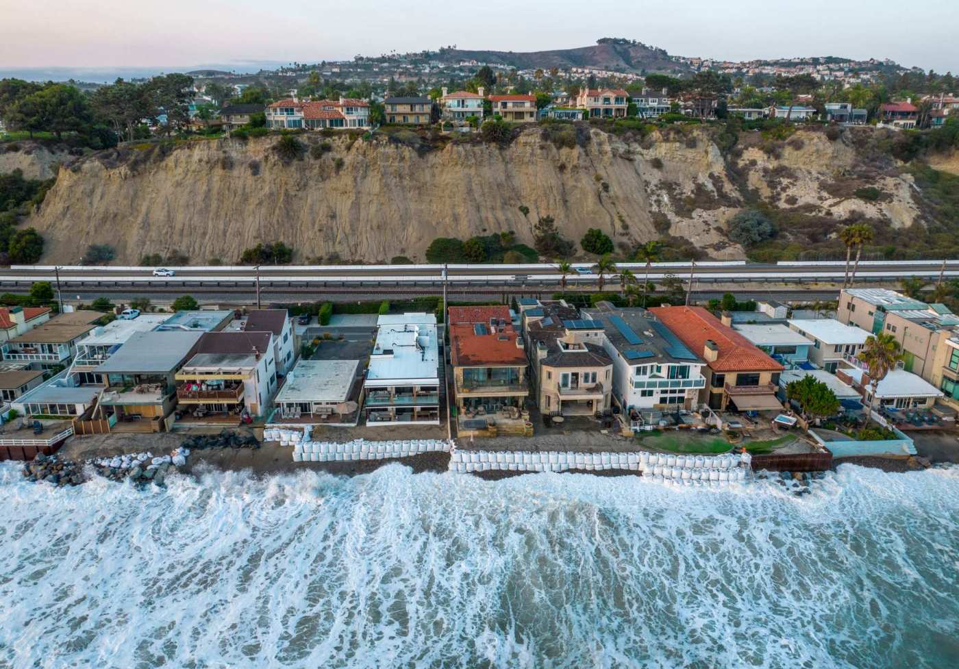
Researchers and decision makers will be able to use the information gathered to better understand coastal flood risks and how to manage the region’s coastline as severe erosion continues in some sections, putting infrastructure, homes and the important recreational space at risk, project officials said. The project also includes the University of Houston.
“We have all these beaches changing quickly and leading to these erosion problems and impact problems – railroads being impacted, State Parks has damaged infrastructure,” said Brett Sanders, a UCI professor of civil and environmental engineering and co-principal investigator on the project. “One of the central needs to manage these problems better is having good data documenting where the sand is accumulating and where it’s eroding.”
Workers build a sand berm to prevent flooding north of the Balboa Pier during high tide in Newport Beach, CA, on Thursday August 19, 2021. . UCI researchers are teaming with NASA to document sand loss due to beach erosion and sea-level rise. (Photo by Jeff Gritchen, Orange County Register/SCNG)
Beaches are more than just recreational space, they offer a line of defense against big waves and high tides, which can batter the coastline and chomp sand away. Sea-level rise combined with human-influenced sand starvation is contributing to beach loss, which can amplify coastal flood risks, Sanders said.
At NASA, there’s an Earth science division people don’t hear much about that identifies issues caused by climate change and the environment, said Ernesto Rodriguez, a NASA research fellow at the Jet Propulsion Laboratory run by the California Institute of Technology in Pasadena.
“When you do it from space, you sometimes don’t have the accuracy,” Rodriguez said. “The partnership with UCI is ideal because it allows us to tie things we can do globally and validate them with what they find locally. If you want to see how the whole coasts of the United States are changing over time, and where sand is going, and how we might mitigate things as sea level changes, then you need to have this big picture that NASA can provide.”
Inland developments and concreting of flood channels have contributed to the siphoning of sand that typically makes its way down to the coast, as do drought conditions that inhibits sand flow down creeks and rivers.
The shrinking of many Southern California beaches can also be traced back to federal projects in the 1940s, with the widening of Anaheim Bay and construction of breakwaters and jetties for the new military bases and harbors. Dredged sand was used to widen local naturally narrow beaches, which require regular replenishment programs to sustain.
Two major replenishment projects that are years behind schedule finally received federal funding this year – the Surfside-Sunset and Newport Beach Nourishment Project and the San Clemente Shoreline Project – earmarking millions in federal dollars for the projects to bring needed sand to the county’s northern and southern ends.
The impact of the delay is starting to show, local officials have said, as the sea creeps closer to homes, businesses and roads that are vulnerable to storm and tide damage.
Capistrano Beach in recent years has crumbled and officials are looking at how to transform the Dana Point beach. In 2020, big surf flooded Balboa Peninsula’s beach parking lots and streets in Newport Beach, stranding drivers for hours with water-filled roadways. Last year, coastal tracks in San Clemente buckled following a strong swell, shutting down the rail system for weeks.
Newport Beach Councilwoman Diane Dixon said the insight NASA can help offer will be useful so “coastal cities could then work proactively with the state and federal governments to look at ways to address and protect these loved and valuable regional sandy ocean beaches.”
A train makes its way north along the coast at North Beach in San Clemente as waves crash against the rocks just below the railroad tracks on Wednesday, October 20, 2021. UCI researchers are teaming with NASA to document sand loss due to beach erosion and sea-level rise. (Photo by Mark Rightmire, Orange County Register/SCNG)
The NASA funded project hopes to collect real-time imagery and data so planners can respond quickly to areas in danger before it is too late.
Sanders’ team currently uses hand-held GPS devices to measure select beaches weekly or monthly, and use drones to document changes along the coast. Although both work well with small stretches of beach, the system can be challenging for an overview of the entire region. Permitting is also difficult and the cost is high for methods, he said.
“This kind of technology can really help coastal communities,” Sanders said of the system the NASA partnership will offer access to. “(Cities) are facing high consultant costs to figure out what’s going on. It’s really expensive to collect good data to really understand what’s happening at the coast.”
Related Articles
Newport Beach asking how pier, McFadden Square area should be renovated
Compromise struck for better lifeguard tower at Moss Beach that’s seasonal
Plans for lifeguard tower at Moss Beach challenged by nearby Laguna Beach residents
Vans US Open of Surfing making major comeback: What to know
Junior lifeguards pay tribute for ‘Ben Carlson Day’
Rodriguez said NASA’s partnerships with universities and public and private entities isn’t new. In California, similar technology has been used to document the snowpack and provide data on the ongoing drought conditions, which in turn state officials and water agencies use to make informed decisions.
But looking at sand erosion is a new venture for NASA, he said. “Beach erosion has huge social impact and importance in California.”
The Synthetic Aperture Radar, or SAR, technology can be put on a satellite and positioned over the coast to collect imagery, Sanders said. It can also take radar measurements to estimate ground elevation, basically making a topographic map from space.
Related Articles
Report: Pilot ‘mobile recycling’ programs aren’t fix for California’s crumbling system
Yosemite fire moves east into Sierra National Forest
Here are answers to 8 common questions about recycling food scraps at home
Approved $10 million project will cut water use by 90% at Laguna Beach marine mammal rescue
Yosemite fire: Why giant sequoia trees are surviving now when others died in recent fires
“We think it is a potentially promising method for beaches. The beaches are changing all the time. A storm can come in and change the beach in a day,” Sanders said. “The satellite often passes a couple times a month. So imagine a future where every two weeks, the coastal communities have an updated map of what the beach sand distribution looks like – where it’s accumulating, where we are losing it.”
The project has already been launched, using Doheny and San Onofre state beaches and Newport Beach as test sites. Researchers will compare the space data with on-ground research.
“We end up relying on a lot of models, often useful, but kind of an educated guess about what’s happening,” Sanders said. “Having better data to support coastal management will be crucial across the US and around the world.”
The NASA data will be free to access and updated every two weeks, Sanders said. The project is expected to run for three years, with hope that within a year there will be a vast dataset available.